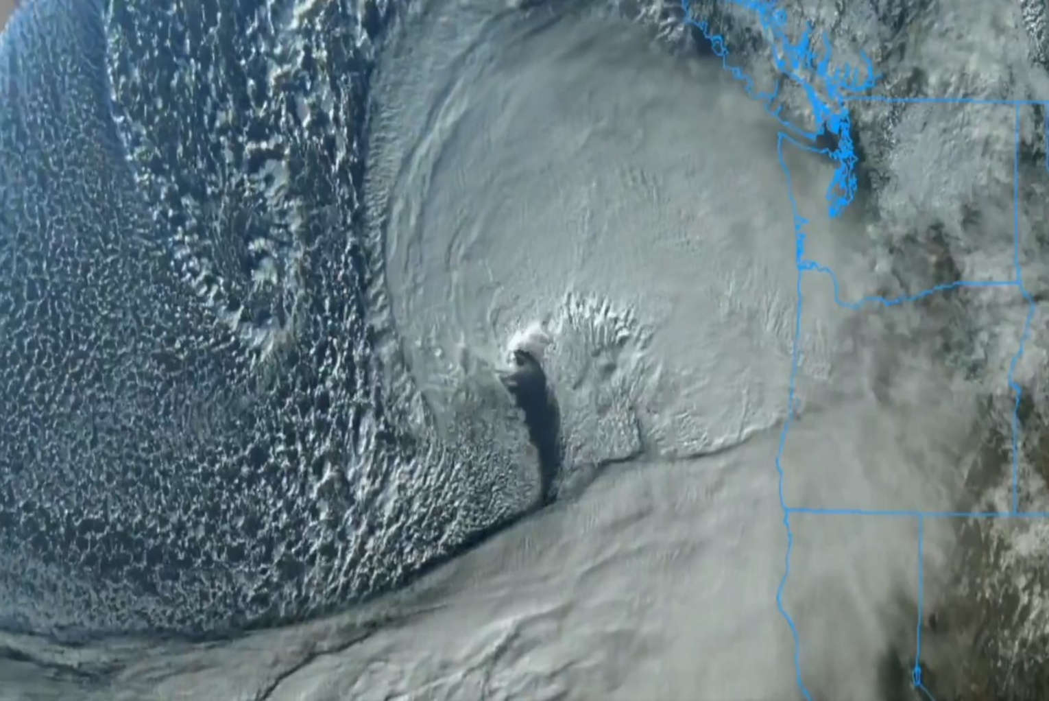
The “bomb cyclone” that is hitting the Northwest is going to be even worse than the experts originally thought. It is being projected that this rapidly intensifying “bomb cyclone” will stall near the West Coast, and that means that some areas of California, Oregon and Washington could get pounded by very high winds and relentless rain for days. In fact, the “Washington Post” is reporting that some areas of California could actually get 20 inches of rain. That much rainfall in such a short period of time would likely cause extremely destructive flooding. In the mountains, there will be blizzard conditions in some areas and the amount of snowfall will be measured in feet.
This is truly an extremely rare storm. Yesterday, I explained that experts were warning that the central pressure of this storm would fall so fast that it would double the criteria for a bomb cyclone.
But now we are being told that this storm could actually become a “triple-bomb.”
A powerful “bomb cyclone” will combine with an atmospheric river to unleash over a month’s worth of rain, hurricane-force wind gusts and feet of mountain snow to parts of the Pacific Northwest and Northern California.
A storm system off the Pacific Northwest is expected to rapidly intensify on Tuesday in a phenomenon called “bombogenesis” and earn it the moniker of “bomb cyclone.” It will intensify so much so quickly that it could become a “triple-bomb,” tripling the criteria needed to be considered a bomb cyclone, the National Weather Service in San Francisco said.
I have never heard of a “triple-bomb” storm before.
Our weather is getting so crazy that they are actually having to invent new terms to describe it.
Breaking News. Spirit-Filled Stories. Subscribe to Charisma on YouTube now!
According to one climate scientist, it appears that this storm will be “one of the strongest low-pressure systems on record in the region.”
The cyclone’s rate of intensification means it could be “one of the strongest low-pressure systems on record in the region,” Daniel Swain, a climate scientist at the Institute of the Environment and Sustainability at the University of California, Los Angeles, wrote on the social platform X. “This very strong low will generate hurricane-force sustained winds well offshore,” generating waves up to 60 feet (18 meters) in height, he added.
Of course the sheer intensity of this storm is just part of the story.
The “bomb cyclone” will be funneling moisture from a Category 5 atmospheric river to the West Coast, and it is expected to “stall along the coast and hammer the area with hazardous conditions through the week and into the weekend.”
This bomb cyclone will work with an atmospheric river, a long plume of water vapor moving like a river through the atmosphere, to wring out heavy rainfall and significant mountain snowfall in the Pacific Northwest and Northern California beginning Tuesday. The pair will stall along the coast and hammer the area with hazardous conditions through the week and into the weekend.
Parts of northwestern California could record 16 inches of rain or more in 48 hours. More than a month’s worth of rain is expected in the northern San Francisco Bay area, primarily north of the Golden Gate Bridge, the weather service there said. Rainfall of this magnitude is expected to cause significant urban flooding, debris flow on roadways and river flooding.
This is going to be a disaster that plays out over several days.
According to Accuweather, we could see wind speeds of up to 90 mph along the west coast.
“The storm’s fastest increase in strength will be from Tuesday to Wednesday, and correspondingly, that is when the strongest winds (50-70 mph) will be felt from the south along the immediate Pacific coast and from the southeast in and east of the Cascades and Siskyous,” Zehr said.
The AccuWeather Local StormMax™ wind gust on Tuesday night is 90 mph, which is close to a Category 2 on the Saffir-Simpson Hurricane Wind scale.
This is not a hurricane, but it will produce winds that are like a Category 2 hurricane.
When I first heard that, it got my attention immediately, and many of you out there know what I am talking about.
According to Axios, just off the coast of Vancouver Island we could see wind speeds of up to 100 mph.
Even stronger winds, of up to 100 mph, are likely off the coast of Vancouver Island and west of Washington state, as the bomb cyclone reaches its peak intensity by Wednesday, before drifting off the coast while weakening into the weekend.
The high winds will do quite a bit of damage, but I expect flooding to do even more.
Accuweather is telling us that some areas will get about a foot of rain, and other areas could actually see a total of about 20 inches.
From Tuesday night to Wednesday, the atmospheric river will be mainly directed at the southwestern Oregon and Northern California coasts. In this area, from eight to 12 inches of rain will fall from Tuesday to Friday with an AccuWeather Local StormMax™ rainfall of 20 inches.
Do you remember how the immense devastation caused by Hurricane Helene caught everyone by surprise?
I think that we could potentially be facing a similar scenario with this storm.
It is all going to depend on how long it stalls off the West Coast.
Interestingly, this is all happening just after a “doomsday fish” washed up on a beach in Southern California.
A so-called “doomsday fish” has washed up on a Southern California beach — typically an extremely rare occurrence, but this is the second time this year it has happened. The rare oarfish found on Grandview Beach in Encinitas measured roughly nine to 10 feet and was spotted by a doctoral candidate at Scripps Institute of Oceanography, the school wrote on social media.
For years, I warned that our planet was becoming increasingly unstable, and at first a lot of people criticized me for saying that.
Not too many are criticizing me for saying such things these days.
We really are living in apocalyptic times, and in the years ahead we will see things happen that are far beyond anything that Hollywood ever dreamed up.
If you live on the west coast, please be very careful over the next several days.
This is a storm that you do not want to mess with.
Michael Snyder’s new book entitled “Why” is available in paperback and for the Kindle on Amazon.com, and you can subscribe to his Substack newsletter at michaeltsnyder.substack.com.


